 Ardahan
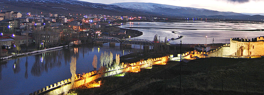
It is the center of the province of Ardahan which is established on the Caucasus on the border of Turkey with the Eastern Anatolia Region and the Black Sea. It left Kars province on May 27, 1992 and became the 75th province of Turkey. With 17,171 inhabitants as of 2009, Tunceli is the smallest province center in Turkey after Bayburt and Gümüşhane.
History
In the year 680 BC, the six godfather Scythians who came from the Caucasus north took the Ardahan region from the Van / Urartu empire. It is known that the Goglik, Taoklu, Cavaklı boilers of their habitats are located in this area.
After the 500 years of domination of the beaks in the region, they continued their dominance in the 600 years of the Part / Arsakli from Iran. (150 BC - 430 AD) It is known that Kuman and Pechenegs lived in this area where Alparslan added to the Selçuklu region in 1068, even during the Macedonian İskender era.
In 1124, the Orthodox Kipchaks from the north of the Caucasus became the settlement place of the Kipchaks, and in 1267 they established a dynasty named Atabek in the Kipchaks Ardahan-Ahiska-Artvin section and in 1479 they were subjugated to Istanbul and they reigned until the Ottoman state armies took Ahiska in 1578.
Geography
Located in the northeastern part of the Eastern Anatolia Region which is adjacent to the Black Sea Region, Ardahan is high and rugged. There are mountains over 3,000 m in the field. The lonely mountains range along the provincial border of Artvin. Keldağ (3,033 m) in the northeastern part of the province and Akbaba Mountain (3126 m) in the eastern part of the province. The southern part of the province's territory also makes the Allahuekber Mountains and Mount Vesuvius (3.197 m) rugged. Kabak Mountain (3.054 m) connected to Allahuekber Mountains remains within the provincial boundaries. Mount Virtuous is the highest point of the province with 3.197 m. Ardahan Plateau is located in the central part of the province. The height is 1800-2000 m. The basis of the Neogene volcanism is the resulting lavas.
Plateau, end of Pliocene and Pleistocene at the beginning of the faulting occurred in the final collapse. This area, which has marly and sandy sediments on the edges, is filled with materials from the high cuts.
The plateau surface is fragmented by the Kura River and its arms. The most important of these streams is the Kura River, which is the platoon from beginning to end. Çildir Lake; It lies in the southeast part of the province, the altitude is 1,959 m. Aktaş Lake is located in the eastern part of the province. The eastern half of this lake lies within the borders of Georgia, the altitude is 1,798 m.
Population Structure
Ardahan, due to the cold, unfavorable climate and unemployment as of the region, has given a lot of migration. According to 2009 data of the Adrese based Population Registration System, Ardahan's urban center population is 17,171. The population together with the villagers connected to the district center was 40.455 and the general population of Ardahan province was 108.169.