Baba Burnu, the westernmost point of Anatolia, and İncirburnu in Gökçeada, the westernmost point of Turkey, are within the borders of Çanakkale. The largest islands of Turkey in the Aegean Sea, Bozcaada and Gökçeada, are connected to the province of Çanakkale. Çanakkale is composed of 12 districts, 22 towns and 565 villages along with the central districts. The largest district after the center is Biga. Bozcaada is the smallest town in the province. The population of the islands does not last twice as much in the summer than in the winter.
When you look at the whole territory of Çanakkale, the peninsula on which it is founded is called the Biga Peninsula. The most remarkable elevation in the province is the Biga Mountains. The reason for the so-called use of Biga name is that it was the Biga district of Sancak in the Ottoman administrative system before the Republican period. In other words, the old center of the province is Biga and in the Republican era, the province name and center were changed to Çanakkale because of the successes gained. The origin of the name is based on pottery craft which is very developed in the region. The city was named Çanakkale when the two icons of the city became identifiable with Kale-i Sultaniye and the pottery.
In the first years of the reign of the province of Çanakkale, the removal of the Biga and Gelibolu banners and the Çanak village, located in the middle of both provinces, became popular. In the 1927 census, Çanakkale's Central Population was only 8,500 people. In ancient times, the province, also known as Hellespontos and Dardanelles, is known to have been inhabited since 3000 years. The ancient city of Troy (Troia, Troy), which still survives today, was destroyed by a great earthquake in 2500 BC and the area was ruled by the Lydians for many years. In 336 BC, Millabat was subjected to a great deterioration on the shores of the Greater Iskender Granikos Stream (Biga Stream), which was intended to spread the Persian Empire Hellenism to the world, the most important force in the region. The destruction of the Karesioğulları Beyliğin in the Ottoman period also seized a large part of the present land of the province and thanks to the reliefs of the Byzantine Gallipoli, the conquest of the province became even easier and the control of the Bosphorus passed through the Ottoman State.
When you look at the whole territory of Çanakkale, the peninsula on which it is founded is called the Biga Peninsula. The most remarkable elevation in the province is the Biga Mountains. The reason for the so-called use of Biga name is that it was the Biga district of Sancak in the Ottoman administrative system before the Republican period. In other words, the old center of the province is Biga and in the Republican era, the province name and center were changed to Çanakkale because of the successes gained. The origin of the name is based on pottery craft which is very developed in the region. The city was named as Çanakkale when the poem was identified with Kale-i Sultaniye, which had two symbols.
Demography
There are 568 villages, 21 districts, 12 district municipalities and 22 municipality municipalities in the province of Çanakkale. With the provinces of Çanakkale, the population is 477,735 km. The population of the city center excluding the villagers is 96,588. The largest district after the center is Biga. Bozcaada is the smallest town in the province. Although the population of the islands surpasses twice the summers, they do not live in the winter other than the inhabitants.
52 percent of the population in the province lives in the rural areas that remain in the cities. With an annual population growth of 10.34 percent, Turkey is far above the average and has an extreme population growth. The population density is 48.16 people / km².
Geography
More than half of the province's territory is covered with forests. Forests make up 53.9% of provincial lands. The forest areas are 536,964 hectares, of which 449,024 hectares are protected and 87,969 hectares are forests distributed and traded, ready to cut. More than half of the woodland is covered with red and oak.
Climate is almost the same in the coastlines of the provinces and islands. The climate in the Çanakkale lands, where there is a transition climate between the Mediterranean climate and the Black Sea climate, is more parallel to the Mediterranean climate. In the inner regions, the altitude increases from the sea, and the average temperature in this region is relatively higher than the coastal regions. Most of the year, windy days are experienced in almost every district.
There is no water mass that is important in Çanakkale. Tuzla Lake in Gelibolu Peninsula, Hoyrat Lake and Lake Ece on the borders of Biga, and some small reservoirs and ponds located in other districts. Approximately 10,000 hectares of Lake Ece, located in Yeniçiftlik village of Biga, are being dried in the last few years and trying to be suitable for agriculture.
The Çanakkale province has geographically four different water masses and coasts.
Culture and Education
Provincial, in terms of education to the people of Turkey provides a much higher than the average. There are 1 Science High School, 10 Anatolian High School, 2 Anatolian Teacher High School and many vocational high schools in the province borders. Canakkale Onsekiz Mart University (ÇOMÜ). It has 9 faculties, 2 colleges and 2 institutes, and 20,000 students are trained. 8.0% of the population is university graduate. The enrollment rate in primary education is 100%. The literacy rate (2000 Population data) is reported as 90%, but it is estimated to be 99% within the last time. (Çanakkale Governor's Official Page) There are 75,000 students in the district. The number of students per classroom is 20.
Çanakkale has remained under the dominance of different societies for millennia and carries traces both in architecture and in life. With the commercial investments that have started to be made since the 70's, the traditional society structure on the right has been rapidly modernized. Transportation has become easier with commercial investments and the change of the appearance of the city has thus begun. Today Çanakkale is Turkey's most modern environment. It is an exemplary city with large pavements, clean streets and well-maintained buildings. Even though the infrastructure is not fully established yet, Çanakkale province is the leading environment in Turkey in terms of culture. The core family is widespread in society. It consists of Society, Immigrants, Turkmen, Pomaks, Yörükler, Circassians and a small number of Bosniaks. Pomak and Yörükler usually deal with agriculture. Pomak with a Yoruk person wear traditional clothes in different ways.
Large examples of modern clothing have been adopted in provincial and district centers. The ladies from the countryside wear white (yemeni) scarves and baggy trousers and black nylon jackets (ferace), while rural men wear dominant clothing, pants, jackets and caps. It is very unlikely that men wear shalwar in the area. The local cuisine has delicious tastes. Key words to describe Çanakkale cuisine; Olive oil, olives, sardines, cheese, and recipe. The islands are the champions of viniculture and wine making.
Tourism
Although Çanakkale and most of the districts are rich in historical and natural beauty, fewer tourists need to be in the region. Almost every place around the city center has been declared a site. This is one of the main reasons why Çanakkale can not grow. Many areas are settled off.
The main attractions of Çanakkale
Gökçeada (İmroz)
Bozcaada (Tenedos)
Warfare Works
Ancient Greek Cities
Goose Mountain
Thermal and Thermal Facilities
Monuments
Castles
Lawn Castle
Çanakkale Naval Museum Command
Hellespont
Canakkale Abideleri
Saros Gulf Saros Gulf located in the north-east part of the Aegean Sea; The Gelibolu Peninsula in the south, and the Thracian coast in the north. Shaped triangular recess. At the eastern end of the gulf, which is surrounded by coasts in the northern and southern geomorphologically marginalized landscapes, there is a marshy plain (Kadıköy-Eski Evreşe ovası) covered with alluvial deposits of Kavak Deresi (Ancient Melas). According to the research, the gulf, which is considered as a graben area collapsed between two fractures which are extension of the North Anatolian fault line, is formed as a result of regression and opening according to some researchers.
Depth conditions are asymmetric. On the Thracian coast a shelf area of 10 km in width and not more than 90 meters in depth extends. There are a few small islands (Donkey Islands) that are not settled to the east of this area. There is no shelf in front of the Gallipoli peninsula and suddenly passes over 500 meters of depth. This deep cut in a flat-tailed gutter view extends westward over Gökçeada and Semendirek Island, with depths exceeding 1000 meters.
Saros Gulf, which is one of the most salty parts of the Aegean Sea, has complicated vortex flows. Because of these currents Saros is a self-cleaning gulf. It is claimed to be one of the five gulfs that have been cleaned and cleaned on their own in the world. Saros Gulf, an important fishery area rich in species due to the high oxygen content of the waters and the abundant nutrient salts brought to the bay, has summer resorts and touristic establishments on both shores of the Saros Gulf. It is among the most popular diving places of sea lovers, especially those who love to dive.
Gallipoli Peninsula National Park is a large park located on the southern tip of the Gallipoli Peninsula within the borders of Canakkale, covering almost all of the Eceabat district, with an area of 33,000 hectares in the European side of the Dardanelles Strait. It was founded in 1973 and is listed on the United Nations National Parks and Conservation Areas.
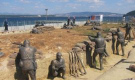
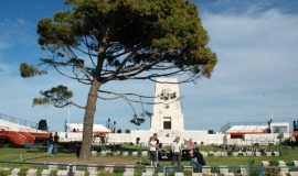
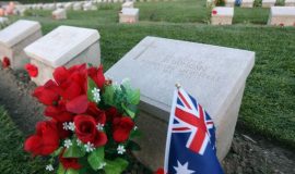
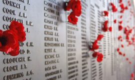
World War I The places where the Çanakkale Sea and Land Battles are made are on the Gallipoli Peninsula. There are also a wide range of submerged ships, tanks, trenches, bastions and hundreds of other remnants of war, as well as war graves and monuments of more than 60,000 Turkish cities and more than 250,000 Australian, New Zealand, British and French soldiers.
Remains of battlefields, war graves, monuments and war were registered as "historical site" and "cultural asset". There are also many "archeological sites and monuments" dating back to 4000 BC. Within a wide variety of "natural sites and monuments" are the beaches, the valleys, the mixed forests with Mediterranean shrubs (stones), stunning geological and geomorphological formations, a salt lake (recently shoreline) and a 15th century military architecture There is an interesting collection of "cultural heritage" that includes examples.
Kilitbahir Castle Kilitbahir Castle was built by Sultan Mehmet the Conqueror in the village of Kilitbahir opposite Çanakkale in order to prevent the Papal Navy from helping the Byzantine Empire during the siege of Istanbul in 1452. The castle consists of inner and outer fortification walls and a 7-storey triangular palace in the courtyard. The inner castle has 7 floors. It was later restored for the first time by Sultan Süleyman the Magnificent in 1541. During this restoration, a tower (Sarıkule) was built at the outer end with a city wall surrounding the southern part. The castle was restored for the second time in 1870 by Sultan Abdülaziz. The original outer sea wall of the northern part is missing today. This part of the northern part of the period 1893-1894 II. It was rebuilt by Abdülhamit. Outside walls (outer castle) 4 m, second outer castle 18 m, inner castle 30 m high. Wall thicknesses are between 4-6 m. The southern parts of the sea walls were used as cannonballs. The castle was built with roughly chipped stone. The openings are tile arched and the doors and windows are made of white marble. The castle played a very important role in the Gallipoli Wars. This castle was registered as "Cultural Asset to be Protected" by the Ministry of Culture on 14 November 1980.
Canakkale Center
Cimenlik Castle The reason for the existence of Çanakkale, Kala-i Sultaniye on the side of the Bosphorus is Çimenlik Fortress, which is called today. Kaleyi, Fatih Sultan Mehmet conquered Istanbul and built it in 1462. Piri Reis mentions that he completed the book here in the Book of Bahri.
The castle is an inner castle with a square plan, and it comes from the outside. It is said that Fatih Sultan Mehmet was seated and addressed to the soldiers in the ancient marble chair which was placed at the entrance of the inner calender. The outer walls of the castle are 100 × 150 m. . The height of the walls is 11 meters. There are 9 bastions on the walls and on the outskirts as floods. Suru III on the sea side of the castle III. Instead of being destroyed during the Selim period, gun platforms and arsenals were built in accordance with that day's weapon technology. During the Dardanelles War, 4 balls were defended in the field. On March 18, 1915, the castle, especially the British ship Queen Elizabeth 's intense attacks, was left in ruins and damaged. Today it serves as a part of the Marine Museum.
Çanakkale Maritime Museum The Canakkale Maritime Museum was built in 1927 with an old military building bearing the architectural traces of the early Republican period. "Ottoman Nuri Nuri Mühendis 1927" and "Mimar Arif Süleyman 1927" are written on the right hand side of the two Ottoman books placed in the main entrance of the building. This building, first used as the Commander of the Provincial Command, then Commander of the Sea Corps, and Military Housing, was turned into a museum in 1982 as a painting and photography gallery. Today, mines are on the ground floor of the building. On the first floor, the photographs of the throat model revolving on the 18th of March 1915, the uniforms, flags, weapons and military materials are displayed. On the second floor, 97 pens and watercolor paintings belonging to Mehmet Ali Laga are exhibited in the fourth period military painters.
In the garden of the museum and in the garden sections of the Laimenlik, various war materials are displayed in open space. It is also part of the navigable section of the museum on the Nusrat Mine Ship on the coast.
Aynalı Bazaar Aynalı Bazaar (or Halyo Bazaar) is a closed bazaar located in Çanakkale. In 1890 the city was built by Eliyau Hallio, one of the elders of the Jewish community. On the door book there are two writings of Ladino with Ottoman and Hebrew letters. It is stated that the Ottoman bazaar was built by "Adülhamid Han-ı Sani El Ghazi (Abdulhamit II) by Elia Halyo bendeleri from Museviyye" (loyalty of the saints). Ladino, according to the Jewish calendar of the bazaar of the tribe in the year of 5650 years "Sultan Abdulhamid II Sultan's reign was made by the order of the 14th anniversary of Eliyau Hallio" was written. The real name of the bazaar is "Passage Hallio". However, he was known as Aynalı Bazaar because of the mirrors on both sides of the entrance. Çanakkale's well-known Çanakkale Turküsü'nın Aynalı Çarşı'nın name is passed.
Çanakkale Archaeological Museum Museology studies in Çanakkale started with the storage of old works collected from the region in 1936 on an old church in Zafer Square. Later, this building was arranged and turned into a director and opened in 1960. In 1984, the new museum built on the Atatürk Street started to be serviced. Cultural and artistic works of the communities that lived in the museum within the period from prehistoric times to the present day are exhibited.
Archaeological artifacts unearthed from the excavations of Troia, Assos, Apollon, Smintheion, Tenedos, Alexandreia Troas Ruins and Dardanos Tumulus are exhibited in museum exhibition halls. These include marble sculptures, grave stalactites, architectural pieces, bronze and terracotta-pottery, candles,
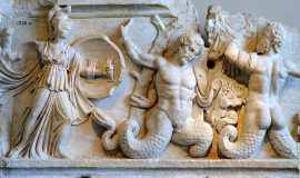
Sculptures, stone and bone tools, glass ornaments, smell vessels and gold. Among them painted sarcophagi that can be counted among the important works, the Persian period sarcophagus painted with Polyksena lahti is exhibited.
Canakkale Surroundings
Assos The city of Assos, on a volcanic hill between the Tuzla Stream and the sea, was visited by immigrants from the island of Lesbos. It was founded in the century. City BC In the 6th century it was under the rule of the Lydians. At the end of this century, like the entire Troas Region, it became a part of the Frygia Satrap in Assos and was taken over by the Persian administration and joined the Athenian Union in the 5th century BC. Satrap Ariobarnazes who rebelled against Persian King Artaxerxes He was defeated in Assos in 365. Then the banker, Eubolos, took over the administration, and then the heir of his heir Hermias became the owner of the city. Hermias was also a student of Plato. The city was included in the kingdom of Pergamum between 241-133 BC. Then, like many Anatolian cities, it was included in the dominion of the Romans upon the will of Attalos in 133 BC.
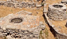
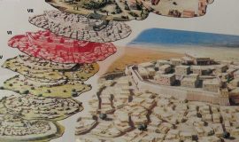
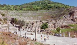
Trojan Troy or the ancient city where the battle of Troy wanders in Iliada, which is one of the two poetry supposed to be written by Trojan Homer. It is located on the skirts of the ancient Ida Mountain (Kaz Mountain) and within the borders of Çanakkale. In the 1870s, the German amateur archaeologist Heinrich Schliemann discovered the ancient town near Tevfikiye village, and the works are largely in Turkey, Germany and Russia. The ancient city has been in the World Heritage List since 1988, and since 1996 it is in the status of National Park.
First, the city, which is close to the sea like the ancient cities of Ephesus and Miletus, was established as a harbor town to the south of the Dardanelles Bosphorus. Over time, the Karamendere River has moved away from the sea due to alluviums it carries on the city's shores and has lost its significance. Therefore, after the natural disasters and attacks that have taken place, they have not been re-enforced and have been abandoned.
The Trojans replaced the Heraclid dynasty of Sardis origin and ruled Anatolia for 505 years until the reign of the Lydian kingdom Candaules (735-718 BC). Ions, Kimmers, Phrygians, and Miletians spread afterwards in Anatolia, then BC. In 546 the Persian invasion came.
The ancient city of Troy is identified with the Athena temple. During the Persian sovereignty, it is stated in the inspirational sources that the emperor first visited Serhas on his Greek expedition, before he crossed the Dardanelles, visited the city during his struggle against Alexander the Great in Alexander the Great and sacrificed to this temple, and donated his armor to Athena temple.
The remains of the ancient city discovered by the amateur archaeologist Heinrich Schliemann in 1871 were found to be the result of excavations carried out in a later time, seven times in the same place - in different periods - and 33 layers of different periods. In order to be able to examine this complex historical and archeological structure of the city more easily, 9 main divisions were divided according to the historical periods of the city, expressed in roman numerals.
Behramkale Assos, now known by the name Behramkale or Behramköy, is 100 km. And 17 km away from Ayvacık. It is located on the edge of a volcano opposite the Edremit Gulf and Lesbos Island (Mytilene), on the Andesit Rocks and is an important settlement center of the Ancient Ages. At the same time, there was a difference of 200m between the sea and the residential area in spite of being a port city. With the fact that the settlement in Assos was not certain, the Bronze Age (3000 BC - 1200 BC) also revealed archaeological studies.
Bozcaada Bozcaada is the third largest island of Turkey and is connected to the province of Canakkale. The surface area of the island is 40 km² and the distance to the mainland is 6 km. Bozcaada is famous for its wine grapes and wines. Most of the island is covered with ties. The beach of Ayazma is definitely the number 1 beach of the island because of its fine grained, golden yellow sand, the surrounding restaurants and cafes. Apart from the Ayazma beach, the Mitos beach and the aquarium located in Habbele Bay can also be preferred. "Grapevine" festivals are held in July. Moreover, it should be seen that the island has a very magnificent palace. Bozcaada is one of the few places in Turkey where wind energy is produced. The location of the Winds of Roses displays an extraordinary view, especially at sunset.
Gokceada Gökçeada is a town of Çanakkale and the largest island of Turkey. It is located at the entrance of Saros Bay to the north of the Aegean Sea. 91 km. Coastal shrubbery. İncirburnu, located to the west of the island, is the westernmost point of Turkey. In the island, olive cultivation has been traditioned for centuries. Approximately 200 thousand olive trees are available. Recently, Gemlik type table olive production has started to be done. There are even 600 year old olive trees on the island. You should take it from the natural '' Island Olive Oil '' when you go to the island. We also recommend you to take it from the soap made with home made wine and olive oil. You can also taste the most beautiful fish of the aegean sea. you can find…
Biga and surroundings
Kalafat Village
This is a 100-year-old Bosnian village. The town center, 3 km. Away. The "Nilufer Lake" in the village area offers a natural beauty. The lake surfaces are covered with lotus flowers. The whole lake is 7 acres. On 2 acres, lotus flowers grow. In the dry season, irrigation was done by the Municipality for the drying of these flowers.
For those who know the Bolu-Abant region, the beauty created by the lotus flowers on the surface of the eyes offers a truly spectacular natural image. In fact, this lake, Turkey, Abant after the lake, the water lily flowers, emerges as the second lake.
Balıkkaya Hill
The district center is located on the skirts of Balıkkaya Hill. While the average height from the sea is 50 meters, the height reaches up to 200 meters on the hill. There's a big rock on the hill. This rocky, slippery stone. There is also a cave in the rock. Inside the cave is a rock that resembles a woman with a baby on her lap. The woman's daughters are believed to be the dairy, and now the water.
Karabiga
This is a settlement. Despite being on the seashore, "Kara" was given the name of biga. I did not understand. Municipal buses operate every hour, from the bus terminal in Biga city center. Yes, Karabiga is about 26 km from Biga. In the north, on the Sea of Marmara. In this settlement of Karabiga peninsula, about 3000 people live. When I go here: I can not believe my eyes. A wonderful sight. There are restaurants by the seaside, where you can enjoy delicious seafood in full accompaniment with the sea view. After the meal, walk along the beach, watch fishermen who are working on fishing boats in the harbor and repairing their nets, fish counter stalls. For those who are really near here, Karabiga is a must-see destination.
Today: Remains of Karabiga known as "Karabiga Kaleleri" probably belong to the "Miletus" colony, which dominated here in the 7th century BC. The name of these remains comes from Priapos, the Country God of Anatolian civilizations. It stands out as a port city. The city gains great fame over time, especially wine made from grapes collected from its vineyards. In 343 BC, the Romans dominated here. Alexander the Great, as I have already mentioned, wins the battle with the Persians at the shore of the Granikos river, now called Kocaçay. The Byzantines, who ruled the region later, deployed the mercenary Catalan troops they brought from Spain and used them in the war against the Turks. In 1364, the city entered the hegemony of the Ottomans. In battle, the city is burned down. The Ottomans give the name "Karapiga" in the meaning of karaşehir on this, smelling of sooty-smelling city. I think I mentioned at the beginning of the article that even though he was on the seaside, why was the name of the carabine given here. Well, that's why you got the name of the carabini here.
Locations: from the center of the settlement, about 3 km. Away. Any official excavation work in the region.
Biga Creek
Çanakkale is located in the town of Biga and the name is taken from this province where the town is located. There are many bridges on the Biga Stream, which divides the district into two.
It is approximately 80 kilometers long and travels through many regions and dumps into the Marmara Sea.
By staying at one of the nearby hotels or pensions near the Biga Creek, you can explore this area. The tea, which is 80 kilometers long, dances to Çanakkale with a great harmony with nature.
The Karabiga area is 3 kilometers away and you can easily reach from Karabiga. Şahmelek Bay One of the most beautiful and attractive places of Çanakkale-Biga; Shahmelek Bay ...
The transportation of Şahmelek Bay is very easy. You can go to Karabiga by private vehicle or you can reach Koya in 45 minutes with Aksaz dolmus, which departs from Biga.
The locals will treat you like one of them, and every minute will be peaceful and pleasant. Just as you will focus on the days you pass, you will throw away all your tiredness from your year and store new energy.
If you stay at one of the nearby shahmelek coves, you will have a wonderful view and you will be witnessed. In this region you will find places to add to your trips. The Legend of Pegasus
When Bellorophon has a winged horse named Pegasus, it gains many victories thanks to it. However, this situation causes him to take pride and ride the Pegasus directly to the sky. However, at this very moment Pegasus bites a horse fly and throws Bellorophon on it. He goes to the sky face.
Biga Great Mosque
It was built by Sultan Mehmet the Conqueror when he served as Manisa Sancakbeyi. Because: When Sultan Mehmet passed to Edirne, he stayed here one night and saw that there was no mosque and hamam in this area. On top of that: the mosque and the bath are ordered and made. The mosque and bath complex
Biga Martyrdom
173 soldiers were buried here, who were wounded during the Çanakkale war and brought to the Biga Harp Hospital and martyred while being treated. At the gate of the martyr: It is seen that the marble written in Meshhet was in 1916. Meşhet means "martyrdom" in Ottoman. The length of the mosque is 45 meters and the width is 40 meters. In the martyrdom: it is in a beautiful monument erected for martyrs. Monument height: close to 6 meters. The Kaida is a "greenish" stone found abundantly in this region. On top of that; There is a marble column in the form of a bullet. Monument: It was built by Mehmet Sadık Usta of Kayseri. The symbol made for the martyrs of Çanakkale belongs to the tombstones: the ones with feebleness and the rugged soldiers with ruggedness. Codes of the martyrs are also written. However, during the Greek occupation these were destroyed by Greek soldiers.
Halimbey Konagi City Museum
This structure was built by Halim Bey in 1900. Its greatest feature is that it is built using a European architectural style. II. The degree has been registered and protected as a historical monument. In 2004, the site was restored and designed by the Municipality as a "City Museum" and opened to visitors.
Kırkgeçit Thermal Facilities
It is within the boundaries of Ilıcabaş village. 18 km from the town center. Away. Biga-Çan highway, 12 km. Away. Water properties: temperature: 52 degrees. It can be used with natural heat without artificial cooling. It is dominated by sulfate and chloride ions and boron. The radioactivity ratio is; 6.5. Sulfur and hydrogen are also present.
Kemer Village
In the village of Kemer, the ancient city of PARİON comes forward. There is no clear record of the meaning of the word Parion. According to the said: "Paris" in the time of Troy had lived there for a while, and in this respect, the city was given the name "Parion" in the sense of "place of Paris". The first installation is thought to be a fishing town, famous for its cousins with "gorgon heads" in the antique age: vineyards, wines and front of the city, which goes up to 8th century BC.
The name of the city of Parion is first brought up by Herodotus for the first time in history. When Dareios, the king of Persia, came to the Scythian expedition in the years of 513-512 BC: the Pariones joined the palace alongside him. In the Athens-Sparta war, the Parions are beside the Athenians. Alexander the Great, after Persian victory, ties it to himself. Later, in the city, the kingdom of Thracian Lysimachos is seen. In 241 BC, the kingdom of Pergamon takes the dominance of the city. In the following period, the Romans capture the city. Famous geography writer Strabon: writes about the city, where it has rich land and ties. Also: this region refers to a nearby "Nemesis". When this temple was demolished, all its treasures and even its stones were demolished, moved to the city of Parion, and built a magnificent altar in the city.
Hisarköy
23 km from the town center. It is within the boundaries of Hisarköy. Here: ancient remains. These remnants are: vaulted bridges and tunnels, theater and inscriptions. It was understood that this was an important spa center during the Roman period.
The most comprehensive study in this area was made by German archaeologists in 1979 and found many remains from the Roman period. However, it is said that sufficient and necessary excavations have not yet been made here.
We depart early morning from Istanbul and drive to Gallipoli peninsula on the first day. You will have Gallipoli Guided Tour and transfer to hotel. You will have a night accommodation in Eceabat or Canakkale. You will find your own way after the breakfast on the nextday.
You will be picked up from Istanbul and drive to Canakkale and arrive in Troy. You will have guided troy Ancient city tour including lunch. At the end of the tour, transfer to hotel. You will stay a night hotel. Nest day you will have breakfast and check out from the hotel.
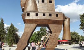
2 days and 1 night best of Troy & Gallipoli tours from Istanbul; This package is one of the best option for all Gallipoli peninsula and Helen of Troy. This two days tour package covers the Anzac part of Gallipoli, Gallipoli Cape Helles part, Troy and Trojan Horse.
Gallipoli & Troy Tours From Istanbul - 2 Days & 1 Night; You will depart from Istanbul and first day you will visit Gallipoli Anzac part and stay at hotel. Next day you will visit Helen of Troy ancient city and drive back to Istanbul. This is door to door service from Istanbul.
You will depart from Istanbul for 2 days guided tour and at the end of the tour, arrival to Selcuk and Kusadasi. You will visit Gallipoli peninsula, Troy Ancient City and Pergamon Ancient City. You package covers a night hotel acommodation.
3 Days Anzac Day Speacial Ceremony Tour covers pick up from Istanbul and drive to Gallipoli. You will have Gallipoli Anzac tour, Helles tour, Troy tour and hotel accommodatation. At the end of the tour, you can continue back to Istanbul or Sekcuk / Kusadasi.
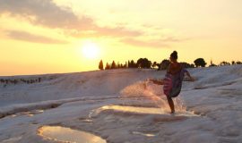
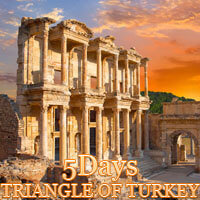
4 days package tour departs from Istanbul early in the morning and drive to Eceabat in Canakkale. We do Gallipoli & Troy tours in Canakkale than continue to Kusadasi. We will have Ephesus & Pamukkale guided tour than flight back to Istanbul.
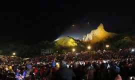
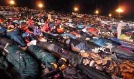
Anzac Day Tours packages covers to pick up from Istanbul and at the end of the tours, continue to Kusadasi and Selcuk. Your Anzac day tou package covers Dawn Service, Gallipoli tour, Troy tour and Pergamon tour including hotel.
This tour is a tour package the History of Battlefields, Antique city with an accompany of a professional tour guide that covers to visit Gallipoli, Troy, Pergamon, Ephesus, Pamukkale's ruins that you will be visiting one by one with the tour guide and have the info about your wonders
See the highlights of Turkey's most popular attractions including Istanbul, Gallipoli and Troy on this fabulous compact tour. Explore exotic Istanbul, the former capital of the Byzantine and Ottoman empires. See the major tourist sites including St. Sophia and the Blue Mosque, the majestic Topkapi Palace, the bustling Grand Bazaar. Drive to Canakkale and visit Gallipoli Peninsula and Helen of Troy ruins.
6 Days Turkey Asia Minor Package Tour cover Gallipoli, Troy, Ephesus, Pamukkale, Priene, Miletos and Didyma tours with professional licensed tourist guides by the Ministry of Tourism in Turkey. Your package tour covers all your transportations, entrance fees, hotel accommodations and domestic flight ticket for back to Istanbul.
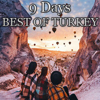
Our package giving you great opportunity, which takes 7 days and 6 nights covering Gallipoli, Troy, Ephesus, Pamukkale, Cappadocia sightseeing tours lead by professional official guides with hotel reservations, lunch services and bus transportatios.
8 day Explore Mystic Turkey Tours programme is departing from Istanbul and visiting Gallipoli, Troy, Ephesus, Priene, Miletos, Didyma, Pamukkale, Aphrodisias and Cappadocia. Tours covers all transportations, hotels, guided tours, entrance fees and flight ticket to Istanbul.
8 Days Discover Turkey package tour is one of the most reasonable and joyfull option to discover Gallipoli Battle area and visit Ancient city of Troy, where you can fallow the foot steps of the history. Kusadasi, Ephesus, Didyma, Priene,Miletos and Pamukkale which are the pearls of Agean Cost which shining like a sea sparkles and Cappadocia, like the Hittite’s called ‘’ Land of the beautifull horses’ which will gonna imperessed you.