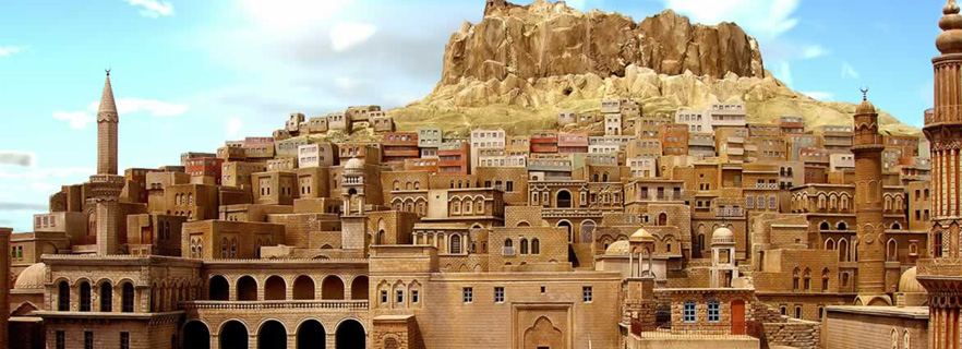
 Mardin
He is a member of the Dicle Division of the Southeastern Anatolia Region. It is the border with Syria. According to the 2009 data, the population is 737.852.
It is one of the poetical cities of the Southern Dense that gives the impression that the architecture, ethnographic, archaeological, historical and visual values and time have stopped. Mardin is home to religious, religious, monasteries, churches, churches, and monuments that are in line with different religious beliefs. Mardin is on the route of Silk Road, there are five inns and a caravanserai on the eastern side.
There are different rumors about Mardin name. Kelimenin is said to be Persian, Greek, Arabic and Syriac.
Geography
Location: Mardin is located in the Dicle Department of Southeastern Anatolia Region. It is the border with Syria. Syria in the south, Şanlıurfa province in the west, Diyarbakir and Batman in the north, Siirt province in the north, and Sirnak province in the east.
Climate
Terrestrial climate characteristics are seen throughout the city. The winter months are cold. The highest temperature measured in the summer is 42.5 (July 31, 2000), and the temperature record in Turkey is also broken (48.8 Mardin, Kızıltepe). 22 February 1985) and the region is under the influence of dust transport from the deserts like spring and summer. Derik, Nusaybin and Savur districts also have Mediterranean climate characteristics. The highest average temperature is observed in July with an average temperature of 35.3 °, with the average lowest temperature being 0.7 ° degrees in January.
Economy
Traditional economic structure is based on agriculture, farming, livestock and trade. Compared to 2001, 66.8% of the economic activities in the previous years were realized in agriculture, farming and animal husbandry. Organic agriculture on the border of Syria does not contribute to the economy of Mardin due to the fact that the suitable land is mined. The next most important sector of agriculture is government services. According to 2001, GDP per capita is $ 983.
There are production and industrial zones in the name of "Mardin Free Zone" and "Mardin Organize Industrial Zone". Due to the inability to complete the Southeastern Anatolia Project, the most important project of the region, the agricultural products based industry has not developed. The share of the industry in total income is 5.5%.
Ida culture tourism, belief tourism opportunities, but Mardin does not have an important place in the economy.
Transportation: The D-400 highway in the east-west direction passing through the districts of Kızıltepe and Nusaybin is the most important highway on the east. Şanlıurfa and Şırnak can be reached through this way. Scheduled flights to Turkey from Mardin Airport 20 km away from the city center.
Health
There are 11 hospitals affiliated to the Ministry of Health in Mardin. There are Mardin State Hospital, Mardin Maternity and Children Hospital and Mardin Mouth and Dental Health Center in Mardin city center. Derik State Hospital, Derge State Hospital, Dargeçit State Hospital, Kiziltepe State Hospital, Kızıltepe State Hospital, Kızıltepe State Hospital, Mazıdağı County Mazıdağı County Hospital, Midyat County Midyat State Hospital, Nusaybin County Nusaybin State Hospital, Omerli County Ömerli District Integrated Hospital, Savur District Savur County Integrated Hospital health [8] As a private institution, Mardin serves 1 hospital in the city center.