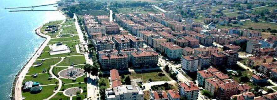
 Yalova
According to today's administrative division, Yalova is composed of 6 provinces along with the central district. Districts; Yalova Central, Altinova, Armutlu, Çınarcık, Çiftlikköy and Termal.
Yalova has a total of 15 municipalities along with 6 district municipalities; There are 43 villages in the central district 1 (Kadıköy), 3 in Altınova (Kaytazdere, Subaşı and Tavşanlı), 4 in Çınarcık (Koruköy, Esenköy, Kocadere and Teşvikiye) and 1 in Ciftlikkoy (Taşköprü) It is built on land.
Yalova became a province on 6 June 1995.
The population of the city was 98,347 as of 2010. The population of 21,000 in 1973 rose to 65,823 in 1990, to 70,118 in 2000 and to 87,372 in 2007.
Yalova, located on the northern coast of the Armutlu Peninsula and the northern skirts of the Samanlı Mountains, is located in the southeastern part of the Marmara region on the north-western side of Turkey. Sea of Marmara to the north and west of the province, Kocaeli to the east, Bursa (Orhangazi-Gemlik and Iznik districts) to the south and Gemlik bay to the south. The borders of the province of Yalova up to the southwest are surrounded by the Marmara Sea.
The shores do not show any indented feature. 39-40º north latitude of Yalova, 29-61º east longitude of 2 meters above sea level, the highest point is 926 meters. The area of 839 square kilometers covers 0.11% of the country's surface area.
Yalova is the smallest province of Turkey in terms of its surface area and is one of the touristic sights which is the longest coast to the sea with 105 km.
Yalova has fertile and fertile oval. Çınarcık, Gökçedere, Kirazlı, Kılıçköy and Taşköprü and the sea are formed by small scale ovals separated by low hills. These ovens extend throughout the rivers and are surrounded by fruit and vegetable crops.
The total area of Yalova (847,000 ha) is 82%, agricultural land (221,730 ha), forest area (468,090 ha) and meadow-pasture land (7,944 ha).
The province produces vegetation cover and forests. The makams located in the valleys to the north and south of the Samanlı Mountains are found in discontinuous strips and fragments along the skirts of this mass.
The steep slopes to the south of Yalova are completely covered with a lush forest cover. In the forested areas are usually beech, oak, hornbeam, cranberry, chestnut and linden trees. From the forests in Yalova, the wood and timber needs are met.
Yalova provincial borders are rich in ethnic and cultural diversity as well as ecological diversity. With the migrations from all over Anatolia, both religious and linguistic diversity has increased. There are settlements of ethnic groups speaking Pomakça, Avarca, Circassian, Lazca, Georgian, Dargish, Kurdish, Bosnian, Tatar / Karachay other than Turkish throughout the province. Also famous names such as Izel, Şebnem Ferah, İbrahim Kutluay and Mehmet Okur are born in Yalova.
History
The first settlements in the region were in the prehistoric ages around 3000 BC. The area was dominated by Hittites in 2000 BC, Phrygia in 1200 BC. The region was conquered by the Romans in 74 BC. After the division of the Roman Empire in 395 AD, Yalova went under the rule of the Byzantine Empire. In 1302, Yalova was controlled by the Ottoman Empire.