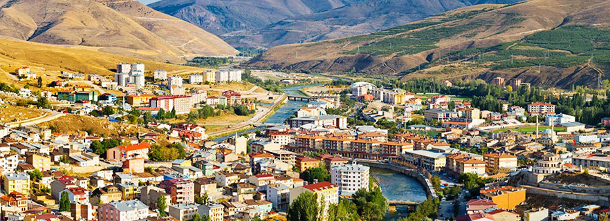
 Bayburt
It is located in the Eastern Black Sea Region of the Republic of Turkey. An important part of the indigenous people is Turkmen / Çepniler. 2010 According to TUIK, there are 3 districts, 6 municipalities and 165 villages with central districts.
history
The name of Bayburt city; During the period when the Urartu / Khaldilis, who spoke one of the old Caucasian languages, dominated the region, the infiltration of the Indo-European-language Mitanni immigrants among the people of Khalt (Halti).
The word Bagbarti comes from Mitannice as it is said by groups coming to the region to settle in Khaltlar.
Known history of Bayburt history begins with Azzi and Hayasalar, one of the rooted tribes of Anatolia. It follows Hatti, Hittite and Urartu.
Even today; The people of the Black Sea say that Halt is the one who settled in the coastal towns (even if not completely), Laz, the inhabitants of the inner and mountainous regions. In the inner parts of the Eastern Black Sea region, the region extending along the mountainous line between Yusufeli and Şebinkarahisar; Khaldia, which means the homeland of those who went to the footsteps of Khalt, the Chief God of Urartu, has been named throughout history.
The region first visited Kimmer in the 7th century BC and then to the Scythians. Urartu is destroyed and the Royal Scythians who came to the region set up Gymnias which is the biggest city of Anatolia according to that turn. It is estimated that the city of Gymnias today is within and borders of KY Bayburt.
For more detailed information on the topic, you can look at Anabasis's book "The Return of Ten Thousand".
Scythian sovereignty After the end of the Middle East, Bayburt, which was within the borders of the state of the "first national state of Anatolia: Pontos", a term Armenian and later Mahmut Goloğlu, famous historian of our region, changed the identity of the Pontos state under the influence of Helen, With the destruction of Rome by Rome.
It is known that Bayburt had been in the Roman Empire for a while and that this empire had been divided into two so that it remained in Eastern Roman territory. According to the organization of the Byzantine Empire, the country was divided into a number of themes similar to the present states. Bayburt was tied to the Heldia theme, bringing four of the seven bishops who brought this province to the waterfall. Bayburt, known to have been fortified and repaired by Emperor Justinianus, was under the rule of the Bagrat dynasty during the Arab conquests.
Bayburt and its region are the regions where Turkmens first settled in Anatolia. During the Anatolian campaign of Tuğrul Bey (1054) he was conquered, although he was subjected to the attacks of the Seljuk forces, which were located in Bayburt, Çoruh River and the Black Sea Mountains (Parhar). The definite Turkish domination took place after the Battle of Malazgirt Square. The city was dominated by Saltuklu Beyligi, sometimes ruled in Erzurum province from 1072 to 1202, and sometimes by Danişmentliler. Although it was occupied by Theodore Gabras, the Commander of Alexis Comnen of Trabzon Emperor for a while, he soon became dominant by the Danisims. (1098) When the Seljuks ended the Saltuklu state in 1202, they also took Bayburt.
The real development of Bayburt was in the period of Erzurum Meliki Mugisuddin Tuğrul Shah and his son Cihan Shah (1020-1230), the brother of the Turkoman Shah Süleyman Shah. Tuğrul Shah rebuilt Bayburt and rebuilt his fortress. I: Alaeddin Keykubad strengthened the borders against the Mongols while Bayburt was bound to Konya with Erzurum. Bayburt was under the control of the Seljuks during the invasion of Anatolia by the Mongols following the Kösegag war. This situation is understood in 1291 by the suppression of money by Kizaseddin Masud here.
It was a place where Bayburt, Genoese and Venetian caravans stayed because of being Turkmen and speaking Turkish and being on the road of Tebriz-Trabzon during the time of İlhanlılar and Safavids. Marko Polo, who visited here while on his way to Mongolia, states that there are rich silver mines in the city. In fact, the Ilkhanids were providing a tax burden from here. At the same time, the city was named as Darül Jalal and became a cultural center. Here Mahmudiye and Yakutiye medreseleri were established, Mevlevi was developed and also the ahilik organization spread.
After the death of the last Ilkhanid ruler Abu Said Bahadir Khan (1334), Bayburt was conquered by the Eretnaites. From time to time the city of Erzincan Beylerinin attacked the city, entered the administration of Mutahharten. But not too long before the time of Kadı Burhaneddin, Kizilbash was taken with the help of Ahmet Bey, the son of Kutlu Bey, one of the Akkoyunlu beylers, and given to Ahmet Bey as an ict. At one point, the city, which was in the hands of the Karakoyunlu people, was again captured by the Akkoyuns and stayed there for a long time.
The Bayburt region was taken in 1501 by Turkmen and Safeviler. In this period, Yavuz, the governor of Trabzon, was invaded in this area (1507). Yavuz sent some of his forces to Bayburt on his Iranian campaign after he had ascended the throne. In October 1514 Bayburt was taken from Shah Ismail. After that, Bayburt Erzincan and Trabzon Beyi Bıyıklı were given to Mehmet Pasha and Sanjak was declared as the center.
In 1541, Bayburt's fortress, which had increased in importance during the Iranian campaign of Kanuni, underwent a major repair. In 1553, although the Turkmen witnessed the influx of Shah Tahmasb, the son of Shah Ismail, There has been no significant incident as a century ago. During the Ottoman-Russian war of 1828-1829, Russian troops invaded. Bayburt was re-occupied by Russians in 1878 and 1916, and was seriously destroyed during these occupations.
Bayburt, which was tied to Erzurum until 1927, was connected to Gümüşhane on this date. On 21.06.1989, the provincial status was reached with the law numbered 3578.
Geography
Bayburt province is located between 40 degrees 37 minutes north latitude 40 degrees 45 minutes east longitude, 39 degrees 52 minutes south latitude 39 degrees 37 minutes west latitude. Erzurum in east and south east, Gümüşhane in the west, Trabzon and Rize in the north, and Erzincan in the south, and an area of 3652 km2 in the north-east of Anatolia at the edge of the Coruh River and at an altitude of 1550 meters from the sea.
Bayburt and its surroundings are generally composed of three parts in terms of the shape of the earth. The first is Bayburt, which forms the western half of the area, the second is the valleys formed by the rivers and the third is the mountainous areas surrounding the area and located in the east half.
The Bayburt rubble measuring approximately 900 km2 has an elevation ranging from 1450 to 1750 meters.
The mountainous area that makes up 45% of the land; The mountains of Pulur (2300 m), Otlukbeli (2520 m), Saruhan (2400 m), Çoşan (2963m), Kop (2600 m) and Çavuşkıran (2850 m) are aligned to the east in the south in the south. In the northern part; Zülfe (2750 m), Kemer (2856 m), Soğanlı (2750 m), Haldize (3000 m), Kırklar (3350 m) mountains are available. To the east of the section on the middle section of the Coruh river; Kaledere hill (2500 m) and Visiting hill (2400 m) are located.
There are numerous plots in Kop and Soğanlı mountains. The Çoruh river was born at the Mescit mountain at an altitude of 3239 meters, entering the provincial borders of the Southeastern Turkey and entering the Çoruh valley, leaving the province. There are also some crater lakes on the Ilin Soğanlı mountains such as Haldizen (Balıklı Lake) and Göloba (Horse Lake).
Economy
Economic life has not changed the basic in historical development. Agriculture and livestock, where trade and industry have not developed, have played an immutable role in the economy since the beginning. As agricultural products, grain varieties, feed plants, sugar beet and fruit and vegetable production are done in a few cases. In general, the vegetable need of province is covered by other ills. Most of the land is barren and it is in Çoruh valley; Irrigation and irrigation are carried out in the ovals of Aydýn'tepe and Sünür.
Livestock is the most important of the livelihoods of the province. The land is very convenient for animal husbandry. Pasture farming is being done. In recent years there has been an improvement towards livestock breeding. Milk cow breeding trials are also ongoing. There is a large increase in the number of beekeeping families in Ilimiz counties and villages, and very delicate scented honey production is being carried out in the province.
Bayburt province is a stop of "Silk and spice road" between Trabzon and Iran which is a very old transit trade route. Economy is predominant in agriculture, animal husbandry and commerce. Apart from agriculture, the economic structure has developed in the form of bringing it from the outside and selling it instead of selling it by way of production.
Historical places
Bayburt Castle: During the Ottoman period, this castle was given the name of the Chinese Fortification Castle. This is due to the fact that purple, green and turquoise tiles are used on the outer surfaces of the castle.
In the eastern part of the castle there is also a church remains which is thought to have been built in the XVIII-XIV century. There is an oiled cave on the western side of the castle
Dede Korkut Mausoleum: It is suggested by Orhan Şaik Gökyay, the poet of the Dede Korkut, that the Turkoman species belonging to the village of Masat near the village of Masat, which is 39 km from the south of the province, is believed to be based on architecture and architecture. Guvenc Abdal Haberti talki, Ali Baba or grandfather Gökyay examining the name of the turbine in 1986 printed "Dede Korkut Stories" in the book by giving the pictures of the turban, Dede Korkut'da belongs to the expression. Old Turkish and 718 dates are read on the mausoleum.
Every year during the third week of July, the grandfather Korkut Culture and Art Festival is held internationally, and activities are organized in the branches such as symposium, exhibition and poetry related to Dede Korkut on the festival during the feast.
Sünür Kutlu Bey Mosque: It is understood that it was repaired in 1538 from the book on the gate of the mosque built by the founder of Akkoyunlular Tural bey, Fahrettin Kutlu Bey. Minaresi has a historical book bearing the date of 1616. It was destroyed during the occupation of the Iranian Shah Tahmasp and this incident is on the inscription on the door. It was repaired in 1538 during the period of Kanuni ...
Aydıntepe Underground City: The city, which is located in Aydincepe district, consists of trenches, 2-2.5 meters from the surface, galleys carved into the main rock without using any building material, vaulted rooms and wider spaces opened by these rooms. Vaulted galleries about one meter wide and 2 to 2.5 meters high expand in both directions in some places. Planned rooms close to 3-8 square meters open this space. Conical holes for ventilation purposes created by surveillance rooms appear to have holes in the walls to illuminate gallery rooms.
It is also said that it may belong to the late Roman or early Christian era, as it is said to belong to the city of Hal-City. As well as in the village of GÜMÜŞDAMLA connected to the county of AydinTepe and preserved until this time the bridge has not lost its glory.
Sarıkayalar Waterfalls: Bayburt-Sarıkayalar waterfalls, which have been separated from the 6km of the Erzurum highway and have traveled 16km further, are at the entrance of the central Sarıkayalar village and two in the village. In the summer months the surroundings have natural beauty that is worth seeing on both sides of the pavilion used as a promenade.
Caves: Çimağıl Cave: It is located at the Taşindibi neighborhood of Çimağıl village, 36 km from the city center. The cave is 600 meters long and consists of 11 sections. The ceiling height is 30 meters, and there are beautiful stalactites and stalactites as well as water accumulations in the cave.
Helva Village Ice Cave: It is located in Helva Village. 33 km from the center of the province, located immediately on the slope of the village in the cave of stalactites and stalagmites formed in the ice.BuZ cafe will amaze those who see cinsten. Despite the height of the air, the cave, which takes its entrants to cold winter months, Ice-cold stalactites, stalagmites, and a thick ice sheet.
Even though there is a large entrance gate, the people of the region used the cave where the ice was not found in the natural ice as a cold storage before the technology. It is a rare beauty formed by the roads.
Yakutiye Mosque: This mosque is on Bayburt Cumhuriyet Caddesi, opposite the clock tower, on the area where the old Yakutiye Medresesin is located. It was held between 1913 and 1915 with the help of the General Directorate of Foundations and Bayburt people. The mosque and minaret are completely cut stone and the workmanship is a beautiful example of the art of stone processing ...
Bent Bath: Bath located near the Coruh River on the edge of Bayburt, was built by Akkoyunlu Hace Ferahsad Bey in the 16th century. The building which has been witnessed to be Nice historical has been renovated many times, but the internal structure maintains its originality. Although not actively used today, it is a place that attracts tourists.
Apart from these, there are also historical and touristic values such as the Upper Hinzeverek mosque, Yakutiye Mosque, Zahit Efendi Mosque, Çarşı Hamamı, Kondolotlar Hamamı and Şehit Osman Türbeleri in Bayburt.