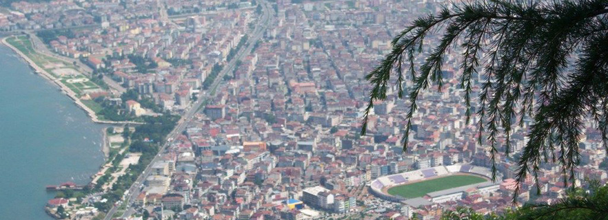
 Ordu
Ordu
Is a member of the Central and Eastern Black Sea Region of the Black Sea Region of the Republic of Turkey. It left Trabzon in 1920, and it got the provincial status on April 4, 1920. According to 2010 TURKSTAT data, there are 19 districts, 53 towns and 481 villages along with the central district in our province.
1963-1964 History of Language and Geography Faculty Prehistory History Professor According to the archaeological excavations and examinations I. Kılıç KÖKTEN made in Ordu, settlement in the city of Ordu and the giving of civilization works. It started in the 15th millennium BC. One of the oldest settlement areas is the Mesudiye district. This district has also acquired many finds belonging to the prehistoric and later ancient bronze devrine. It is seen that the Hittite and Phrygians are dominant in the region.
The first settlement in the city of Ordu was BC VIII. Miletian colonists started in the century. The place of the first city established with the name Kotyora (Cotyora) by the colonists is unknown today. Ordu lands were also the scene of Medler and Persians. It is an important occurence that the Ordu's antiquity arrives during the Riks of 10 thousand BC in 400 BC and the stage of the speech of the famous Xenophone. Cotyora, ruled by Hellenistic, Roman, Byzantines, began to lose importance and vitality over time. After that, Kipchak / Kuman was founded by the name of Bayramli in present-day Eskipazar, 4 km south of the city towards the middle of the 14th century after the Ordu province of Cotyora, which was under Ottoman rule by the Seljuk Turks (Ayazoğulları, Danişmentliler, Hacı Emiroğulları). Bayramlı town lost its former vitality in the early 18th century, and a new district center was born in the west with the name bucak. Bucak name was changed to Ordu in 1869-1870. This new district center was connected to the Bolaman, Thursdays, Ulubey, Hansamana (Gölköy) and Aybasti districts.
While Ordu District was an accident center connected to Trabzon Vilayet until 1920, the Fatsa accident connected to Canik Sancağ and the Ordu was connected to Ordu by the Law no. 69 dated April 17, 1920 and numbered 69 "Ordnance for the Establishment of Independent Military" and a separate Ordu Live was established. In 1923, the name of the province was changed to province and today it has taken its place as the present state of the state of taksimata Ordu. As it is known today, there are 18 villages, 5 springs, 65 municipalities, 505 villages and 327 neighborhoods. The armies of our Ordu, which collects the unique natural beauties of the Eastern Black Sea region, Akkuş, Aybastı, Çamaş, Çatalpınar, Çaybaşı, Fatsa, Gölköy, Gülyalı, Gürgentepe, İkizce, Kabadüz, Kabataş, Kumar, Kumru, Masudiye, Thursdays, Ulubey and Ünye'dir. With its natural beauties, it has a structure that is going to become a tourism paradise of the future. Golkoy, famous for its expanses, historical monuments (Habsamana Castle, 52-step water cistern, historical baths) and its lakes, is at the top of places worth seeing. Especially the Jihadiye Village has become the most important stopping place for the people of Yayla.
According to the Hittite Tablets
B.C. In the 17th century, the Ordu was the country of Kaşkalar and under Hittite rule (1700-1200 BC). After the Hittites, the area was dominated by Phrygians (1200-670 BC) and then by the Kimmers (676-546 BC). The Greek historian Xenophon referred to the Mossinoiks, Khalibs and Tibarenes as the local people of the Ordu region in his book "The Return of the Tens of thousands" (BC 431).
The Tibarenes, an assassinate people, lived between Wednesday-Ordu. Khalibler, who lived between Giresun and Ordu, then spread westward to the Tibenan country where the iron mine was abundant; The centers have become Unknown.
During the Kimmerian period, trade colonies formed in the coastal area of the Miletos. After Kimmerler, the domination of Med and Persians (BC 547-334) passed. Macedonian Alexander ended the Persian rule. From then on the region was ruled by local tribal chieftains for about 50 years. In 280 BC, the kingdom of Pontus founded by Mithridates from the native kings of Iran originated in BC. 280-M.S. It lasted three and a half centuries of life between the ages of 63, but there is no detailed information about it. Vl. It is known that Pharnakes, the son of Mithridates, dominated this area and because of his name he was called Pharnakia. This king spoke to the Romans for 25 years and eventually surrendered. Thus, the Pontus coast became Roman and Byzantine.
The main phenomenon that has changed the ethnic structure of the region is not these political events, but M.S. In 324, the dissemination of Christianity in the region began to Christianize the indigenous peoples and to learn the Greek language.
When Latinos seized the Byzantine capital of Constantinople (Istanbul) in 1204, Alexios and David of the Komnenos family founded the Trabzon State (1204-1461) with the help of Gürcüler. Sultan Mehmet the Conqueror lifted this state. However, the Ordu and the region were conquered not by the Ottomans, but by the struggles of other Turkish groups, especially Haci Emiroğullarin, in a long period extending from 1270 to 1380. XII. At the beginning of the century, there was the Trabzon State (1204-1461) in the territory of the Black Sea stretching from Samsun to Rize and the summit of the Canik Mountains. Istanbul was in the hands of the Latins. The Iznik State was established in Western Anatolia. Apart from these, all of the Anatolian Seljuks were invited by XI. Has been opened to the Turkish government since the 19th century and a strong Muslim Turkish civilization has been established here. The Seljuk State, which opened from Sinop to the Black Sea, undoubtedly threatened Trabzon.
The Trabzon campaign conducted by Seljuks did not yield any results. However, the Trabzon State was generally dependent on the Seljuks. However, the peaceful survival between the two states continued until the invasion of Anatolia by Ilkhanians in 1243.
Mongol domination in Anatolia took a short time, but led to major changes in the structure of the region. The most important reason for this change is that many Turkish tribes, along with the Mongolian invasion, It was that he had emigrated to Anatolia as it was in the 20th century.
It was difficult for the Ilkhanis to control this tribe. Already the last Ilkhanid governors revolted against the center. For these two reasons, XIII. In the second half of the century and XIV. Many Turkish principals were founded in Anatolia at the beginning of the century.
Among these principals, there were Kadı Burhaneddin State, Ayazma Headquarters (Ayazoğulları), Bayburt and Erzincan Beyleri, Headquarters of Milas (Masudiye) Haci Emiroğulları Principality and Headquarters of Taceddinoğulları Headquarters, which were the central Niksar, which replaced Eratnals in Sivas. The Trabzonans were in contact with this state and the peoples and Akkoyunlular, a Turkish confederation in Eastern Anatolia.
The Ordu and its surroundings were conquered by the Turks. In the 15th century, Trabzon palace historian, Chronic of Panaretos, who had researches about relations with the Turkish Principalities around Trabzon State and Aziz b. The works of Erdeşir-i Esterabadi named Bezm u Remz; It is rare to give us information about the history of the Ordu.
According to the sources in these sources, the XIV of the Trabzon Empire. It is seen that the relations that are continuing with the Turks during the first century of the century and the relations that continue with the mutual raids in the first half of the century have tried to create a peace atmosphere by marrying the girls of the Trabzon Emperor to the Turkish Beys and creating a peace atmosphere.
Trabzon Emperor, who had the opportunity to walk on Konya in 1276, was able to walk on Konya and attacked Sinop in the sea in 1277. However, some of the Turkish groups went to the east following the Samsun coastline; On the other hand, the Turkish groups that made the plateau in the Black Sea mountains started to descend from the Harşit Stream, Aksu, Melet Suyu, Bolaman Stream and similar valleys. The distance from the springs to the shore is about 70-80 km. Such a short distance could have been conquered over a period of 120 years, probably due to the mountainous nature of the land. Twenty conflicts between 1297 and 1380 are described in the Diary of Panaretos. These conflicts were conquered by Bayram and Süleyman Beyler from the Hacıemiroğulları Beys, not to return to the Middle Black Sea Region again in 1396. The Turks settled in the region with all their assets, with their families, establishing their own regulations by implementing a collective government policy.
According to this Tahrir Book, which was built by Fatih Sultan Mehmet in 1455 and published by the Turkish Historical Society, the official name of the Ordu region is Vilayet-i Canik Bayramlu me'a Iskefir and Milas. These names clearly show that an Ordu organized in the form of the squads has captured and governed the Ordu territory.
It was conquered and ordained by the Haci Emiroğulları in the Ordu Region precisely in 1390, 65 years before the imposition of the year 1455. These are the boys and the tribes who settled in the area after they organized the military units and conquered the region. The part where each division was placed became an administrative unit, and the name of the person who was at the beginning of the conquest was given as the administrative name. E.g; Bucak Bedir (lü), Ebulhayr Kethüda, Alibeğece, Fidaverende and so on.
Among administrative unit names, there are six names except for person names. One of them is the Ordu biography Alevis. This is the name of the community where Hacı Emiroğulları is a member of his family. These also form a separate division. This name actually comes from the tradition of naming the Turks' state center as the Ordu. The village of Ordu, the center of the Taceddinoğulları Beyli and still preserves its presence in the south of Çarşamba today. Others are Elmalu, Kıruk-ili, Milas (Masudiye), Hafsamana (Gölköy) and Bolaman.
The conquest of the Ordu territory is not like a conquest of a country or region of professional armies, because it was carried out with the participation of family members rather than soldiers. It has been adopted as a dormitory. It is a form of conquest and ishkanism that is applied in a large part of Anatolia during the Seljuk period and forms the basis of the population and culture structure in this country (Prof. Dr. Bahaeddin Yeduyıldız).
Historical and Natural Assets
Ulugöl: The crater is located 17 km from Gölköy district center. There is a wild hunting hunt on the lake which is 250 m in diameter. The surrounding area is covered with forests. It is suitable for camping. Work on opening tourism is ongoing.
Hoynat Island: Thursday is one of the most important historical elements of our city. The bird that seagulls and cormorants live is the paradise. It is known as the only place where horned cormorants nest in our home.
Ünye Castle: It is a 2500-year-old castle located 5 km south-east of the town, on a hill to the left of the road at the 7th kilometer of Unye-Niksar highway in the district of Ünye. The castle is in the village limits.
Gölköy Castle: Gölköy is located at the Kale district. It was built with a single-door wide area. He was in control of the county, convenient for surveillance and defense. To the left of the fortress entrance is a cylindrical bush and watchtower. It was taken by UNESCO in 1997 to the List of World Ancient Works.
Bolaman Castle: It is a chain built along the coast of Eastern Black Sea. For surveillance and police station duty, it consists of two parts, internal and external. The inner castle is located at the western end of the castle, with very high walls and cut stones. A wooden mansion was built on the inner castle in the 18th century. This house, known as Kademoğlu Konağı, was built as a double-glazed on the inner castle. Our territory is an example of civil architecture.
Taşbaşı Cultural Center (Old Prison-Church): Ordu province center Taşbaşı Mahallesi is in the urban SİT area. It was built in 1853. It has been used as a cultural center since April 10, 2000.
Paşaoğlu Mansion (Ethnography Museum): Ordu Museum is located in Selimiye Mahallesi (on Boztepe road) in the city center. Among the registered works in our city, the mansion with a very rich stone workmanship was built by Paşaoğlu Hüseyin Efendi in 1896. 19th century. The mansion, which constitutes the most beautiful example of our civil architecture, is three floors with the floor.
Paşaoğlu Mansion; It was expropriated by the General Directorate of Monuments and Museums of the Ministry of Culture and Tourism in 1982 and the mansion, which was completed in 1987, was opened as "Paşaoğlu Mansion and Ethnography Museum". There are 2,121 pieces.
Osman Pasha Fountain: The Governor of Trabzon, originally Ordulu, was built by Hazinedarzade Osman Pasha in 1842. It was demolished in 1937 and rebuilt in 1997 by the Ordinary businessman Fahri Çelebi in accordance with the original initiative of the Ordu Municipality. In our country the columns are the highest fountain.
Boztepe: Ordu city is laid on the slopes of Boztepe. It is 550 m high from the sea and it is unsatisfying to watch all the beauties of our province, the magnificence of the Black Sea from Boztepe. It is possible to reach the city center by 6 km asphalt road. Eating-drinking and recreation facilities and wooded picnic areas are available.
Yasonburnu Peninsula: It is within the boundaries of Çaytepe village, which is 15 km from the center of the province and 28 km from the center of the province. There is a church on Yasonburnu built in 1869.
Çaka Beach and Recreational Area: It is located near Çaka Beach Hoynat Island which is one of the most natural corners of the town. Rare beaches away from ecological pollution. There are facilities to answer all kinds of needs at Çaka white sand beach.
Efirli Beach: Efirli Beach, located in the eastern part of the province of Ordu, is one of the most important holiday places of our province for many years. Efirli beach, known for its public holiday camp sites, serves food and beverages, music and entertainment in the summer months. The beach has observation towers, lifeguards and jump piers.
Spas: the most important of the healing waters of our province is the Ivy Spas in the province of Fatsa.
There are 85 rooms, a 236-bed facility, baths and row baths, belonging to the Ordu Province Special Provincial Administration, which is reached by a stabilized road of 10 km after the Bolaman Stream in the east of Fatsa.
Geography
The province of Ordu is located in the Eastern Black Sea region of the Black Sea Region between 41 ° north parallel and 37 ° and 38 ° east meridians. The north of the province covers the coastal lines of the North Anatolian mountains. These mountains, which begin to climb close to the coast, go up inwards. The Ordu, Giresun and Sivas are adjacent to each other and 3,000 m in age. Ordu and Giresun are the same provinces. The highest peak of the province is the Submission Tepesi in Ashut Obasi, which is near the border of the gorse.
Climate
In the province of Ordu, the climate of the Black Sea is seen. However, the number of cold days in winter is limited to one or two days due to the decrease of mountain hikes from the back. With the increase of the province to the inner cities of the province, the cold is more intense around here. During the winter months snow falls in the inner regions for 6 months. Especially the central spring is very cold with very snowing. These are indicated as Çamþaşı yaylası Beşiktaşı yaylası and Yellow obasi plate. The snow does not melt until around May.
Industry
The industry in the Ordu is not very developed. But the 3 most important factories of Turkey are in Ordu: 1-Right Chocolate Factory - Sarelle, Tadelle, Gool, Gofy and Sagra products are distributed here. 2-Çamsan Laminate Flooring 3-Altaş Oil Industry Inc. - Çotanak branded nuts, corn, canola, sunflower, soy and ideal oil are produced. The factory also produces cleaning products. In addition to these, hazelnut factory concrete companies and so on. There are many small factories as well. The Ordu has developed in the food groups such as hazelnut, chocolate, hazelnut oil. It provides income with these.
Boztepe: Boztepe, one side of the Ordu with a view of the Black Sea on one side of the Black Sea, one side of the green hills are dominated by visitors who are fascinated. Every year thousands of tourists weigh. Especially in the summer months, people take to the hill just for the scenery.
The restaurant to meet your needs like food and beverage at Boztepe. There is also a picnic area between the pine forests. In the winter months his hair falls to white, Boztepe dances with snow and white and green.
Activities such as paragliding are now being carried out in Boztepe. Recently, many beautiful places are believed in the future in terms of tourism.
Ulu Lake: Gölköy is located in the village of Süleymaniye and Haruniye villages. It is the most beautiful place to visit. The festivals are organized here in the summer.
Culture and art: There are many theaters and cinemas, and regular cultural events are organized. The Ordu is a land belonging to the Eastern Black Sea Region with almost all cultural characteristics, although it is a land belonging to both regions, which is a land in the Central and Eastern Black Sea regions in geography books. Turkmen / Çepni culture is the dominant.
Ordu folk music and traditional folk dances show similarities. In the region where the instruments such as bağlama, kemençe, drums-zurna, drums-clarinet (local expression gnnata) are used together, the games are mostly welcoming and horon.
Clarinet is accompanied by plays such as Ordu Welcome, Giresun Reception, Giresun Sallaması, Georgian Horonu, Perşembe Male Horonu, Drunk Welcome, more in Vona (Thursday), Ordu Headquarters, Gülyalı, Kabadüz, Ulubey districts together with drums. In terms of cultural characteristics, the Ordu and its districts show similar characteristics but also contain many differences.
Horon is a popular game of Ulubey, Kabadüz, Gürgentepe, Gölköy, Mesudiye districts, which are mostly located in the south of the coastal provinces and the Ordu Central District. Some of the villages of Ünye, Fatsa, Vona (Thursdays), as well as the coastal provinces are executed in the districts of Gülyalı. Welcome games are one of the most popular game types in Ordu. In this game, Bolaman is mostly performed in (some) districts of Vona (Thursday), Ordu Center, Gülyalı, Kabaduz, Ulubey, Gürgentepe, Gölköy, Masudiye. The welcome is known as the Ordu Reception and the figures are different from Giresun Reception. However Giresun Reception is also being performed in the region. Welcome music usually has the same features as Giresun. In Ordu, Oy Gemici Gemici, Nut Collecting Girls, Bağlamam Curtain Curtains, such as the welcome games are played with plenty.
The region is in the region affected by Ordu-Giresun mouth. The mouth that is used between Ünye-Beşikduzu (Vilayati Çepni) is a common mouth. This mouth should not be confused with Trabzon, Rize and Artvin mouths.