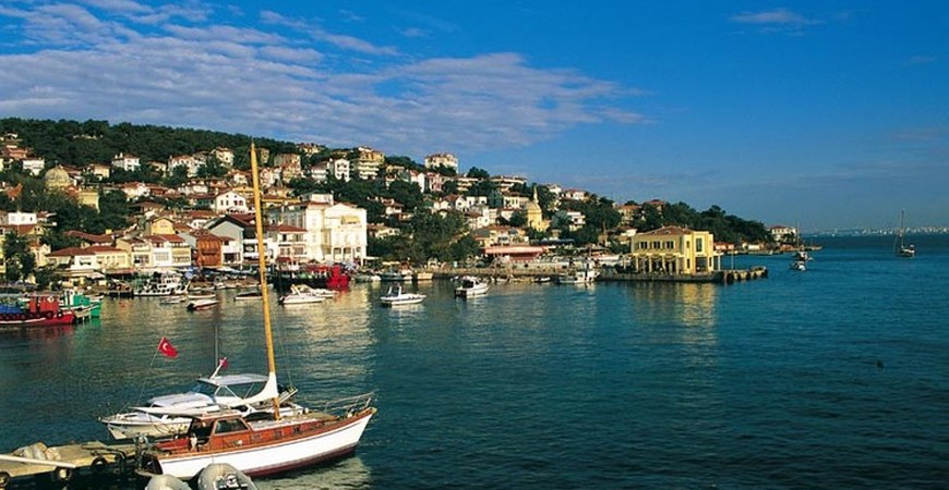
Princess Islands
The Istanbul Islands, known as Islands in Turkey, are the archipelago of the Marmara Sea on the Asian coast, south-east of the southern tip of the Bosphorus. The islands are the maritime neighborhoods of Istanbul, the ancient Byzantine Constantinople, the great metropolis of the Bosphorus. The archipelago consists of nine islands, but the ones outside the five are small and there is no permanent settlement. Although they are located at the nearest fifteen and twenty-six kilometers farthest from the ferryboats at the entrance of the Golden Horn and the Bosphorus, they seem to be far from Istanbul in terms of image and atmosphere.
Nine Islands
The closest island to Istanbul is Kınalıada (Proti), then Burgazada (Antigoni), Heybeliada (Halkki), and finally the largest and most crowded Büyükada (Prinkipo) among the islands. The ferry is also in summer (Anterovithos) in Sedefadas. In Kaşıkadası (Pide-Pitta) there are some residents in summer, but there are no settlements in Tavşanadası (Niandros), Yassıada (Plati) and Sivriada (Oksia).
Buyukada (Prinkipo)
Büyükada, Prinkipo in the name of Greek; It is the greatest and best of the Prince Islands. This is the only island that many people visit and visit, and it is one of the most popular summer resorts. The area of 5.4 km2 is bigger than the sum of the other three main islands. It is also the most populous of the Adalar, in terms of population. The population, which has an average of around 6,500 during the year, reaches 40.000 in summer.
The island is about 4.3 km from north to south and 1.3 km from east to west. There are two high hills: 164 m in the north. (Hristos) Hill in the south, and Hagios Georgios (Aziz Georgios) in the south. Yüce Tepe in height. Yüce Tepe also constitutes the highest peak of the island.
Most of the north of the island is full of constructions; The southern slopes are dominated by forests of lovely pine groves and other trees, wild cliffs to the sea and sandy, deserted beaches.
Heybeliada (Halki)
Heybeliada2 is the second largest island in Heybeliada with an area of 35 km2. While the average population during the year was around 5,500, this number rises to around 30,000 in the summers. The Greek Cypriot name of the island, which means “copper”, comes from the copper mines operated in antiquity in the island; Aristotle mentions these works. Ada, the name of Heybeli in Turkish, because of the resemblance of the “saddle” of the hills and the valleys passing through these hills. Among the main hills of the island, Ümit Tepesi, which is known as Papaz Mountain (85 m.) And located north of the island, is located at the center of Değirmen Tepesi (136 m.) And Köy Tepesi (128 m.) And southwest Baltacioglu Tepesi ). The most important part of the town is the northeast coast; Island houses, Ümit Tepesi, Değirmen Tepesi and Köy Tepesi, as well as the villa between them.
Burgazada (Antigoni)
Burgazada Burgazada is the third largest island in the archipelago with an area of 1.5 km2. The average population of around 1,500 people during the year increases to 15,000 in the summer months. While the island was known as Panormos in the early ages, it took the name “Antigoni” in the Byzantine period. This name is still used by the Greeks. The Greek word “pyrgos”, meaning “tower”, comes from a watchtower that is mentioned by Evliya Çelebi and other travelers who lived in the pre-19th century and is located at the summit of Ada. The name of Burgas used by the Turks was formed by the change of shape of “pyrgos” over time. The engravings made by Cosimo Comidas in 1794 are also at the peak of this watchtower island. In this engraved island, it seems to consist of a fruit garden and two or three cultivated fields on the slope of the hill.
Bayraktepe, also known as Hristos Hill (Jesus Tepesi), the island’s only hill, is located in the middle of Adan and is 170 meters high. The center of the village is on the northeastern coast of the island and the settlement extends from here to the higher parts of the north coast. The coastal road reaches all parts of the island, except for the southern coast, which is hardly possible with the steep cliffs rising from the sea.
Kınalıada (Proti)
Kınalı is the island with a size of 1,356 square kilometers, the smallest of the four major islands. The island takes its name from the color of sandstone cliffs standing upright in the sea to the east. Greeks say “Proti” to the island or “First” because the city is the nearest island. Kınalıada has three hills in the north-east: Çınar Tepesi (115 meters), Central Tepesi Tepesi (110 m.) And Manastir Tepesi in the south. The population of the island is around 300 people in winter, up to 15,000 in summer. The village spread on the slopes of three hills in the northern and eastern part of the island. The village center is the ferry pier on the northeastern coast, just as it is in the other three major islands. The new pier for the sea buses is right next to the ferry pier in the south.
Sedefadası (Antirovithos)
Sedefadası Sedefadası, which is the Aramaic name “Antirovithos”, is located about 1200 m to the east of Büyükada’s center. The mother of pearl is the fifth largest island in this region; Dimensions are 680 to 250 m, gore to sea level is the highest point is 55 meters. The name of the island comes from the mother-of-pearl stone, or from the pearl, which is a lot of plants here. Although it is forbidden to enter the area where the villagers of the islanders or their guests other than the islanders or their guests are located, a pebbled beach along the coast is open to the right side of the restaurant and the pier on the pier. The most beautiful part of the island is the part of the eastern coast surrounded by cypress and pine trees and many other kinds of trees.
Sivriada (Oxia) and Yassidaada (Plati)
SivriadaSivriada and Yassıada, west of the other islands in the archipelago, 16 to 17 km from the entrance of the Bosphorus. South and 15 km from the Asian coasts. It remains open. You can get to this island by means of marine engines you can rent from any of the main islands.
The Greek name “Oxia” of Sivriada is “Plati” of Yassidaada. Approximately two kilometers from Yassıada. Sivriada, located on the north-west, is the smallest island between the two; The reason for the fact that Yassidaada has a summit higher than twice the summit of the Yassıada is more striking than the other.
Yassıada Turkish and Greek names are also indicative of these differences and in both cases the same meaning: Sivri-Oxia means “pointed” and Yassi-Plati means “flat-flat”. Yassıada is also known as “Haysızada” and is still used by some local people.
Tavşanadası (Neandros)
Tavşadası is the name of the “Neandros”, which is 2 km from the southern tip of Tavşanası Büyükada. Is in the open. Tavşanadası can be reached by sea engines that can be leased from the pier here. This is the smallest area in the region after Kaşıkadası with 10.000 square meter area. The highest point of the island at sea level is 40 m. Within the islands, it is the farthest from Istanbul. The most beautiful part of the island is the southern coast, consisting of numerous rocky birds and seagulls perched on the rocks like a guard, and steep rocks rising straight to the sea.
Vordonos Island (Vordonosi)
There are Vordonos rocks in the middle of Kınalıada and the Asian coast. The rocks are the remnants of Vordonos, some 1,000 years ago, which arrived today from a small island, sometimes shown as part of the archipelago. Although very small, it was hosted by a patriarch named Photius in a Byzantine monastery built in the second half of the 9th century. The remains of the monastery are under water and the only other abode of the island is the sea lighthouse.