 Kastamonu
Kastamonu province is located in the Black Sea region of the Republic of Turkey and is located on the shores of the Black Sea border with Sinop, Çorum, Çankırı, Karabük and Bartın.
Districts
Districts of Kastamonu with the plate number "37"; Abana, Ağlı, Araç, Azdavay, Bozkurt, Cide, Çatalzeytin, Daday, Devrenkani, Doğanyurt, Hanönü, İhsangazi, İnebolu, Küre, Merkez, Pınarbaşı, Seydiler, Şenpazar, Taşköprü, and Tosya.Kastamonu center population: 91.100; The central district population together with the villagers, total: 125,000 people.
Vehicle: It is located on the Kastamonu - Karabük highway, which is 44 km away from the city center.
Azdavay: Surrounded by rugged and forested land with a surface area of 1268 m² on the north-west of Kastamonu province. Şenpazar and Doğanyurt districts in the north, Daday district in the south, Pınarbaşı district in the west and Küre and Ağlı districts in the east. It is 74 km from Kastamonu via Ağlı-Seydiler . The district consists of 53 administrative units, 49 villages and 4 neighborhoods. Çatak Canyon is located within the borders of Çatak neighborhood of Ahat village in the province.
Bozkurt: It is a town with a coast to the Black Sea. The county seat is not on the beach, 2 km south of Abana.
Cide: The distance to the city center is 133 km and it is on the Black Sea coast. Cide, which is 12 km from the beach, has maintained its position as an important harbor on the Silk Road throughout history. In the district there are wooden ships and yacht shipyards.
Daday: Distance to the city center is 32 km. When Ataturk came to Kastamonu on 23 - 31 August 1925 he visited the town and was hosted in Köpekçioğlu Konağı. Population is 4800. There are two high schools (Daday High School) - (Daday Imam Hatip High School), a boarding elementary school (Professor Doctor Fahri Ecevit Boarding Primary School) and two primary schools (Atatürk Primary School) - (Miralay Halit Bey Primary School).
Taşköprü: Kastamonu is 41 km away. The height of the sea is 500 m. And the Gökırmak Plain, the International Culture and Garlic Festival is held every year in the first week of September. The district center has a planned and regular settlement and it is the second center after Tosya with the most population. It is famous with garlic and well kebab. Kastamonu- It's on the way to Sinop.
Devrankan: Distance to the city center is 29 km. Devrekani mound and ruins, which is an old settlement center, is rich in archeological direction with fountains and mosques. 23 - 31 August 1925 Atatürk visited the town of Kastamonu on 28 August and visited the village of Bozkocatepe - Kurukavak in the forest of Müftüoğlu Mehmet Bey, a wooded area.
Hanönü: It is 69 km away from the center of the province. While it is a township (sub-district) connected to Taşköprü, it has been turned into a separate district. Sheikh Shaban-i Veli Ilçenin, one of the most important deposits of Kastamonu, was born in Mt. "Şeyh Şaban-ı Veli Memma Week" is held in the first week of May in the district.
İhsangazi: The distance to the city center is 37 km. Haraçoğlu Mosque and Tomb located in Ilşenin İsalar Mahallesi is the place to visit.
İnebolu: It is 90 km away from the city center. The district center is an urban site. There are 347 registered buildings. Abeş Tepesi and Geriş Tepesi Archaeological Site are registered as important sites.
Küre: The distance to the city center is 61 km. Doganlar Castle located in the district BC It was built between 1700 and 1100. The globe is a sophisticated forest that is suitable for tourism and natural beauty. Yaralıgöz The canyon in the skirts of the mountain is worth seeing.
Pınarbaşı: It is 92 km away from the city center. There is still warm water in the Roman period "Ayazma" in the village of Ilıca. It is the second largest canyon of the world, Valla Canyon, and the fourth largest cave of the world, Ilgarini Cave. There is another canyon called Horma Canyon. İlçenin was decided to be a district in 1987, became a district in 1988, and the first municipal organization was established in 1989. The population of the center is 1700 and the village is 5174. The town has a mansion called Paşa Mansion and it is located on Uzunam Village There is a stone with writings. The district is a tourism center if enough advertising is made.
Şenpazar: The town, which is 100 km away from the city center, is 37 km away from the Black Sea and 335 meters above sea level.
Seydiler: It is a town located on the Kastamonu-İnebolu road, 30 km away from the city center.
Tosya: The distance to the city center is 70 km away. It is located on the Devrez River and on the E-80 Highway. It is the district center with the highest population after the central district. It is famous with Pirinçi.
Historical
The known history of Kastamonu begins with the Hittite Empire. After the Hittites, Phrygia and Lydia dominated these lands. In the 4th century, the Persians passed away. B.C. In the 4th century BC, along with Alexander the Great, Kastamonu lands were added to Macedonia.
After the Alexander occupation of the region Pontus kingdom BC. It was abolished by the Romans in the 1st century BC. Kastamonu M.S. who remained in the Roman Empire for many years. In 395 the Empire was divided into the Byzantine Empire like all Anatolia.
Roman and Byzantine period
Today, it is located in the area called Paphlagonia (Pophlagonia), which includes Kastamonu and its surroundings and on behalf of the Romans.
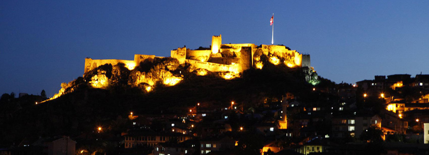
The time when the Romans were the provincial center of Taşköprü (Pophlagonia) Kastamonu is a small town and has begun to develop during the Byzantine period and especially during the rule of the city, the hometown of the Komnen descendants from the imperial dynasties. A castle was built here at the time of this dynasty and it was called "Kastra Komneni" in the meaning of the Comnens' castle. Over time ( "Kastamonu", "Kastamonu") became the present shape of this balm as the Turkmens settled in the region.
Seljuk and Ottoman era: Kastamonu came to the forefront of the Turks who escaped from Turkestan and Iran in front of the Mongol invasion, the cities most affected by the second wave of immigration and many Turkish boys who could not hold up against the Mongols in Central Anatolia took shelter in the northern part of Ilgaz Mountains, Kastamonu. Almost all of the twenty-four Oğuz necks are dormitories around Kastamonu, and Turkish tribes like Alpı, Alpağut, Danishmendli, Kipchak, Karluk, Çiğil and Yağma have also settled in Kastamonu. Places such as Kayı, Bayat, Çavundur, Kınık, İğdir, Afşar, Kıyık, Büğdüz, Bayindir, Çepni and Karaevli, which are still alive in Kastamonu, express very well the nature of Oguz residence. In the 1260s, Ibn Sa'd gave this city the name "Capital of the Turkmen" [citation needed]. According to his record, in those days 100 thousand tent people were piled up in Kastamonu region.
Kastamonu was first handed over to the Turks in the time of Danişmentliler "Ahmet Gazinin Son" in the period of silver tekin "1105" was realized. Nearly 100 years ago, the city and its surroundings, which had been under the administration of the Danişment, were restored by the Byzantine Empire for 15 years and were taken over by the Seljuk commander Hüsamettin Çobanbey under the order of Anatolian Seljuq Sultan Sultan Alaaddin Keykubat in 1213.
The army under the control of Şemsettin Yaman Candar, who was appointed to the police for the second time by the Mongols, went to Kastamonu in 1292 and misled Muzafferettin Yavlak Arslan union and himself was killed. Mahmutbey, the son of Muzafferettin Yavlak Arslan, entered the struggle to get his father's revenge, and Şemsettin Yaman managed to drive Candar from here to the west. After the death of Şemsettin Yaman Candar, Süleyman Pasha re-arrested Kastamon in 1309, expanded his territory and established "Candaroğulları Principality" and ended the domination of the Shepherds.
During the campaigns organized against the Byzantine Empire during the establishment of the Ottoman state, the Turks established in Kastamonu gave an intense support to the Ottoman Principality.
The famous traveler Ibn Batuta who visited Kastamonu in the 1333s said that "Kastamonu is the biggest and most beautiful of the cities in Anatolia ... I have not seen a cheaper place in any country than this city." [5] The light of the size of the city and the availability of living conditions Keep it.
After Isfendiyarbey, Kastamonu, also known as "Isfendiyaroğulları", became an important scholar and cultural center until the Ottoman administration in 1460, educated many scientists and maintained this characteristic in Ottoman times.
Kastamonu participated in the Ottoman state after Fatih Sultan Mehmet took this city together with Sinop in 1460 and removed Candaroğulları's name from the middle.
Kastamonu, which is an important provincial center in the Ottoman period, has been the administrative center of Sinop, Çankırı, Zonguldak, Bolu, Corum and the region up to Üsküdar for a long time.
Kastamonu, who had never been subjected to enemy invasion since his passing to the Turkish domination, is one of the illiterers who gave the most martyrs in Çanakkale and Independence War. He gave 2,527 martyrs in Çanakkale War. The famous "Çanakkale Türküsü" belongs to Kastamonu'un Aşık Yorgansız Hakkı.
National Struggle and Republican Period: Kastamonu made great benefit because it is the most reliable region in terms of logistic support during the National (National) Struggle. In particular, food, clothing, money, ammunition and weapons were sent to Ankara through İnebolu-Kastamonu. And in the War of Independence, ildir sent the most soldiers to the front.
After the proclamation of the Republic, the Great Leader Mustafa Kemal Atatürk's clothing and hat revolution in Kastamonu between 23 and 31 August 1925 passed on to the history pages as a significant event of the Republican era. This time, "culture, past and art week" has received the name.
Provincial Structure
Administrative Structure: In Kastamonu Province, the number of districts is 20 and there are 21 municipalities and 1071 villages including the center. It ranks second in Turkey in terms of the number of villages. There are also 2,558 settlement units connected to the villages.
Physical Structure: Sinop is in the east of Kastamonu, Bartın and Karabük in the west, Çankırı in the south and Çorum in the south-east of the Kastamonu province in the Western Black Sea Region of Turkey. In the north, it is surrounded by the Black Sea. Kastamonu located on 13.108 km2 area constitutes 1.7% of Turkey's land. The height of the city center from the sea is 780 mt. It opens with a coastline of 170 km to the Black Sea.
Soil Structure: Due to climate, topography and main substance differences in Kastamonu Province, various large soil groups have formed. Some types of land lacking of soil cover are also seen. Kastamonu A large part of the local soil contains organic matter rich in forest land. It is suitable to make irrigated agriculture cultivation on all kind of dry agriculture and irrigable areas as much as the climate and physiographic structure permits. Agriculture can be done for this reason.
Cultural Structure
Kastamonu, which is the center of important civilizations dating back thousands of years and developed as a city of culture, is one of our rich history and archaeological wealth riches.
Kastamonu is one of the important centers of the Anatolian Turkish-Islamic culture. It is a cultural center that has been built in the Beylikler-Seljuk-Ottoman and Republic periods after the conquest by the Turks, and some of the architectural artifacts and place names And also in traditions.
Among the major historical-cultural works worth seeing in the city are the glass, the complexes, the medreses, the castle and the castle.
Sheikh Shaban-i Veli Kulliyesi is the largest and most important religious tourism center of the province. The complex located in Hisarardı district; Mosque, Tomb, Asa Water, Fountain, Library and Wooden Houses. It was enlarged in the Külliyede by the constructions between 1575-1900. In addition to this, there is a mausoleum of Maliriye (Bayrakli Medrese) located in the Karin Evliya Tomb, Aşıklı Sultan Tomb, Atabey Gazi Tomb, Hepkebirler Tomb, Müfessir Alaaddin Tomb, Hatun Sultan Tomb, Sheikh Mehmet Efendi (Sacayaklı Sultan) Tomb, Yılanlı Kulliyesi, Nasrullah Kulliyesi, , Benli Sultan Külley is among the other major tourist spots.
Kalenderağa rock tombs in Tekkeşin and Ömerli villages, Berat rock tombs in Emirler village, İnönü caves in Kayali village, Arı in Kavak village, Kebap village in Kavak village, Pampeipolis ruins in Taşköprü county, Kastamonu industrial vocational high school, Ev-Kaya meadows, Ismailbey Şehinşah rock tombs, Arslantaş burial chamber, Rock, Molla Ahmet rock on Baltacık, Ilgarini Caves on Pınarbaşı are some of the archaeological sites.
Kastamonu Museum of Archeology and Ethnography is a collection of National Art and Cultural Remains of the Western Black Sea region. The museum building was planned by Architect Celaleddinbey in 1909 and it was built in 1910 as the Union and Progress Club. During the War of Independence, Kastamonu Youth Organization was later used as the Independence Court. Later, the People's Party and the Turkish Ocağı continued to operate here
Mustafa Kemal Ataturk's visit to Kastamonu on August 23, 1925 declared the hat and clothing Revolution in this building. Atatürk summarizes the decision to implement the hat revolution in Kastamonu and the reason for it in his own words: "You do not know why I chose Kastamonu. Wait, let me explain. All the provinces know me; Either in uniform or with a fierce, hearty civilian dress. I did not go to Kastamonu alone. At first they get used to it, Turkey sees me like that, they do not care. Moreover, almost all of this province has passed through the army of soldiers, they are obedient and compassionate. I will wear the hat there for this. "
In 1940 the building was used as a Warehouse of Ancient Works. In 1952 he became a museum director. The museum exhibits cultural remains and ethnographic artifacts of various civilizations from prehistoric times to our time with geological fossil remains.
Geographical Structure: Kastamonu is located in the Western Black Sea region between 41 ° 21 'north latitude and 33 ° 46' east longitude. The height of the center is 775m. The surface area is 13,108.1 km². This country constitutes 1.7% of the territory.
The Kastamonu Province is mostly composed of rugged terrain and the western Black Sea Mountains in the north of the province. Parallel to the Black Sea coast, the Isfendiyar (Küre) Mountains are located to the north of the provincial center, and to the south the Ilgaz mountains with an extension to the east and west. Gökırmak, Taşköprü and Devrez Stream, which are two important branches of the Kızılırmak River, pass through Tosya. Valley-ovals around two rivers form the most favorable areas of Kastamon's agriculture.
It covers a large part of Turkey's extension to the Black Sea. From the junction of the Çatalzeytin district with the Sinop in the east, to the Kerempe nose in the west, the coast extends in a straight strip. Kerempe Bringing a prominent bulge to the northeastern coast, the coast continues to the border of Bartın province in the south west direction. The length of this coast to the Black Sea is 170 km.
74.6% of the surface area of Kastamonu is mountainous and forested, 21.6% consists of plateau and 3,8% consists of rub. As can be understood from the distribution, there is no large areas suitable for agricultural cultivation. However, the small plains around the valleys are striking. The most important ones are the Gökırmak, which includes the plains of Daday and Taşköprü, and Devrez Vadis, which covers the Tosya agricultural area. There are also planting and planting areas in the vicinity of Vehicle Cide and Devonian tea beds.
In addition to this, there is a separate section named Yaralıgöz Dağı (1985m.), Göynük Dağı (1770m.), Dikmen Dağı (1471m.), Kurtgirmez Mountain (1450m.) Güruh Dağı (1493m.), Ballıdağ {1400m. Elek Mountain is a significant upgrade. To the south of the province lies the Ilgaz Mountains. These mountains are high and continuous. Gökırmak and Vehicle Stream in the north and Devrez Stream Vents in the south. The highest point is Çatalılgaz Hill (2565m.).
Natural Plant Cover
In Kastamonu province, forests and bushes constitute a significant proportion (64%), forests are more frequent (56%), and Kastamonu is more frequent on mountain sililes extending along the coastline to the center of the provincial center. These regions are frequent forest areas. The forest is covered with fairly frequent forest cover. The forest is generally made up of leaves such as Beech, Oak, Kavak, Chestnut and Cinnamon with the poplar trees such as Kızılcam, Karaçam, Sarıçam, Fir, Juniper. In addition, shrubs such as Ormangülü, Çobanpüsküülü, Kocayemiş, Blackberry, Wild hazelnut are also seen. There is a rich undergrowth with high rainfall and high humidity.
There are various kinds of wheat and leguminous plants in the areas where there is no tree cover and are used as pasture without agriculture. Apart from this, there are some barbed plants in places where the veil is broken.