Cesme
HISTORY
It was estimated that Cesus was founded on the western coast of Anatolia for 1000 years BC It was thought that Cesus was one of the 12 Ionian cities of ERYTHRAI (ERITRE) Ildır İskelesiydi. It is believed that the present name of Cesme is taken from “fountains”
Today ERYTE had a great economic power in the 7th and 8th centuries BC. In this period, the city was in possession of the captive and wine trade with the Eastern Mediterranean Private Cyprus and commercial associations (CHIOS) – SAKIZ Island.
It is understood that ERITRE from Troy mounds was founded after the Trojan War. LYDIA (LİDYA) After the Persians stopped and suffered great damage, in the 14th century BC it became a rich city again. In the 2nd century BC, the city was connected to the Kingdom of Bergama and later to the Roman Empire. During the time of the Romans, it took the name of CYSUS, the division of the Roman Empire in two by the Byzantine territory lost its significance, and most of the antique buildings in the city were burned and destroyed, especially during the fortification of Puta and the gods.
ERITRE and Çeşme region which belonged to the Byzantine Empire in the Middle Ages first passed TURKLERIN at ÇAKA BEY (1081 AD). ÇAKA BEY, the first Kılıçarslan’s father-in-law, seized KLOZEMENE Yarımaday during the Seljuk period and today, he built the area and a house between the 2 kms south of Çeşme Village and settled the Turks from the Oğuz Boy. Çaka Bey, a primary school commander who opened to the Aegean Sea, made the Aegean Sea with a light fleet (1085) built in Izmir and gave successful naval battles against Byzantine sea domination. Çaka Bey’s nearly year-long successes have lost considerable power with his death, and his replacement brother, Yalvac Bey, has not prevented the Byzantine reign.
It is believed that the name of ERITRE is pronounced as ALIIRI at the time of ÇAKA BEY. Fatih Sultan Mehmet is a documentary that remained at the time, because of the abundance of hunger gardens around here, it is written as İLDEREN. Again PİRİ REİS is clearly read the name of BİLGİ in the book-i FAHRİYES’de. The excavations in Ildırı in 1963-1966 excavated the ancient theater on the northern slopes of the acropolis, first believed to have been built in the late 3rd century BC. The remains of the Athena temple were found in research conducted on the highest level of the acropolis. 5 km from the city. It can be understood in its length and figs from pots, pottery, stone and earth dating from the 6th and 7th centuries BC were found in the acropolis.
The city, which was re-connected to the Ottoman Empire by Yıldırım Beyazıt during the Ottoman period, was re-connected to Aydınoğulları by Timur after the 1402 Ankara War and again passed through the Ottoman Empire in 1422.
After the First World War, Çeşme was invaded by Greece, sharing our homeland. But after the War of Independence on September 16, 1922 Fahrettin Altay Pasha was cleared of enemy occupation by troops.
Cesme has the most important monument, the Çeşme Castle. Çeşme Castle was built by Beyazıt II in 1508 during Ottoman times.
The Kervansaray, which has a courtyard and two floors inside the Çeşme, was built in 1529 during the reign of Sultan Süleyman the Magnificent and the architect Ömer Bin Ali PAPUÇCU. The plan is u-shaped. The baths next to it complete the complex.
It has many historical fountains to be understood from the name of the district. The water balance in the cemetery section was as robust as it was in time. There are three important fountains known as Anonim Çeşme, Kaymakam Fountain and Molla Fountain in various parts of Çeşme from the 18th and 19th centuries.
GEOGRAPHICAL STRUCTURE
İlçemiz is a beautiful town located on the far side of the peninsula, which carries its name and is surrounded by the sea on three sides in the west of Turkey. Its territory is in Urla District in the east, Aegean Sea in the south and west, and Karaburun District in the north. Çeşme is 80 km. And 8 miles to Chios Island in Greece.
According to the cadastral data, the length of the coastline of the province is 133 km.
In Cesme, which is under the influence of the Mediterranean climate, the mountains are in the other Aegean Coasts, and the landing of the sea has created natural beauties which are always valid raw materials. The land is usually covered with rocky and rocky hills and consists of small ovaciches, which are scattered among few plains. The land is mostly inclined. The forest is small and in bad condition. There are no steady flowing streams. The soil structure is pebbly, sandy, calcareous, and in some regions it is thin and calcareous. There are no underground and aboveground energy sources.
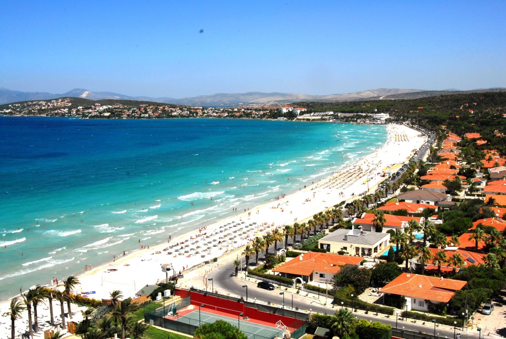
Area of the province is 260 km. Both domestic and international tourism has the number of beaches in Turkey. Countless villagers, clear waters, sunsets, fine sand and boiling sulphurous waters, and beaches with natural attractions are scattered among the various villages of 29 km from the peninsula.
There are 20 sandy beaches known as Şifne, Küçük Liman, Paşa Harbor, Brillant, Tursite, Çatalazmak-Çiftlik, Dalyan and many more.
There are radioactive water sources scattered in various directions of Ilıca Quarter and feeding the public beach in Ilıca. Hot spring waters, which have almost always different compositions, attract the attention of native and foreigners.
There is hot water with sodium chloride at the sea side at a distance of 5 km in the province. Some of these waters boiling in the sea are the most important sources called Topan and Hamidiye.